
Substantial new evidence identifies a lush area in the western corner of Oman as the possible location where Nephi built the ship that carried Lehi's family to the promised land.
Most Book of Mormon scholars agree that Lehi took his family south out of Jerusalem, down the Arabah and south to somewhere near Aqaba. From there Lehi angled on a southeastly direction paralleling the Red Sea coast of Saudi Arabia. Lehi's journey likely took them through or near Medina and Mecca, two holy cities of present day Islam. About 300 miles south of present day Mecca is an oasis called Al Kunfadah, the place Lehi called Nahom, the place where Ishmael died and was buried. From here Lehi turned nearly due east and crossed the lower portion of one of the most barren deserts in the world (The Empty Quarter).
The route Lehi took paralleled the ancient Frankincense Trail. Frankincense is a vegetable resin from the Boswellia, a family of decidious shrubs or trees found in northeast Africa. The resin hardens when dried, into small yellow grains, which are then burned for their aromatic quality. It is called "frank" because of the freeness with which it gives forth its odor. The resin is often burned as incense, used as a fragrance or as an embalming agent. Frankincense came, anciently, primarily from Sada, Yemen (northeast of San'a, Yemen). San'a, anciently, was the terminal point of the Frankincense Trail, a well known and much travelled trade route between San'a, Yemen and Sidon, Lebanon. But the trail continued east from San'a, though much less travelled. Lehi likely followed, or paralleled, this trail to somewhere near Salala, Oman.
Travelling nearly a thousand miles across southern Saudi Arabia, Lehi arrived at a place he called "Bountiful". Lehi describes this area as a place of "much fruit and also wild honey...and we called the place Bountiful, because of its much fruit." This is a startling declaration considering Arabia was a place known for its barrenness, its desolation, and for its lack of trees. Indeed, according to Hugh Nibley, "The best guide to Arabia at the time...imagined forests and lakes in the center of the peninsula, while insisting that the whole coastline was 'a rocky wall...as dismal and barren as can be: not a blade of grass or a green thing' to be found." It was no surprise that critics in Joseph Smith's day hooted at this story.
Even after Europeans explored the real Arabia and discovered that it truly was a barren, desolate desert; where could possibly be the forested area Nephi used to build his ship? The very idea was preposterous. The area described in 1 Nephi had to meet several conditions: 1) timber adequate for building a large sea going vessel, 2) iron ore in nearby mountains for fashioning steel tools and instruments, 3) high cliffs above the sea, 4) fruit trees, 5) fresh water, 6) animals that provided meat. All of these seem incongruent with contemporary knowledge of the Arabian peninusla.
There have been few who have actually travelled to Saudi Arabia to attempt to find a place that could possibly meet all these criteria. Bertram Thomas did so in 1928, the Hiltons in the 1970s, two Australians, Warren and Michaela Aston, in 1992, and finally Maurine and Scot Proctor. As expected from the various reports over the years since Bertram Thomas, Arabia does have a tiny stretch of verdant coastline, made green by the monsoons that pelt this corner of the land and nowhere else. This forest is Arabia's surprise, an anomaly in a land of sand and mountains like the moon.
But the Astons wanted more. They wanted to test the land against Nephi's description to see if any specific location matched. Nephi gave us many specific clues about his Bountiful. Clearly, it was coastal, accessible from the interior along a reasonable route. What's more, it was fertile, a place of "much fruit" and honey where the group could grow crops to maintain themselves as they built a ship. For a place to qualify as Bountiful, it had to have timber in enough types and sizes to permit ship building and a mountain prominent enough to be called "the mount," close enough that Nephi could retreat there and "pray oft."
Bountiful also had to have ore from which metal could be smelted, a source to make fire, and probably a cliff by the sea where Laman and Lemuel could have made good their promise to throw Nephi into the deep. With this comprehensive set of clues, the Astons combed the coast and seriously considered six areas as candidates for Bountiful. Only one of the six was a fit, a tiny beach only a kilometer and a half wide called Wadi Sayq, nearly on the border between Oman and Yemen.
On either side of the beach are 2,500-foot cliffs that drop straight into the sea, making access impossible along the shore, but the wadi (like a dry river bed) cuts its way 15 miles through a steep canyon into the interior. This is the beach's only entrance, difficult enough to travel that even though the beach basks glorious and green in tropical sunlight Wadi Sayq is remote and forgotten. To this day it is uninhabited.
Was this the place where Nephi built the ship? The Astons were compelled enough by the match between Wadi Sayq and Nephi's description of Bountiful that they published a paper detailing their research for FARMS, the Foundation for Ancient & Mormon Studies ("And We Called the Place Bountiful: The End of Lehi's Arabian Journey").
Another couple who visited the area is Maurine and Scot Proctor who rented a Jeep in Salala, about eighty miles east of Wadi Sayq, and drove west toward the location they believed best fit the description of Bountiful. Wadi Sayq drops off the western plateau at about the 4,000 foot elevation. From here the wadi drops four thousand feet in sixteen miles to the coast. The wadi is barren and desolate and gives no hint of its lush ending near the sea. The only practical access is from the sea, by boat.
Wadi Sayq is one of two "rivers" in Arabia that flow near the shore with water all year round. Trees abound with "much fruit" available in the form of date-palm fruit. Dolphins frolic in the waters near the beach, wild flamingos wade in the fresh water. This is a place that perfectly matched Nephi's description. A free-standing mountain occupied the southwest of the beach. Towering tarmarind and sycamore trees suitable for shipbuilding grew up in the wadi a few hundred yards away from shore. Here was a freshwater source, sardine in the sea for eating, land and water to grow crops.
Large sycamore, tarmarind, and boscia trees, 60 to 80 feet high, grow in abundance about a half mile from the beach at Wadi Sayq. Sycamores are excellent shipbuilding lumber and could have supplied Nephi with the lumber for his ship
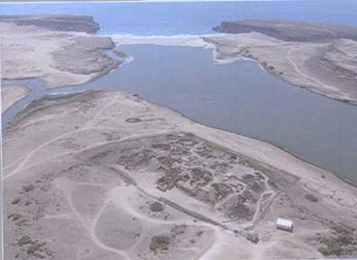
The Astons had written that they had found archaeological remains in Wadi Sayq, signs of former human habitation. They reported that on the east side of the wadi stood a mound some twelve feet high and forty-five feet in diameter, now covered with wind-blown sand and vegetation. Radiating from this mound, they noted, were double lines of stones. One of them stretched about ninety feet toward the beach. A second double line of stones, some 400 feet long, curved back toward the freshwater of the wadi. They also reported a rock face, not far from the mound that contained several groups of graffiti. Though some of the graffiti looked relatively recent, sketched on the rock was what appeared to be a much older set of graffiti, its red pigment faded with time. Painted in that faded red on the rock was a ship.
The Proctors began their exploration of the wadi on the opposite side from the mounds, they started to see double lines of stones everywhere. One line over 600 feet long stretched perpendicular from the beach, back into the trees. Another at right angles to it ran across the valley. Who had built these double lines, and for what purpose? Further down the wadi, a foundation was visible. Not far away were several three-feet high stone structures shaped like an omega. A little farther, we saw the remains of an ancient well.
The oval mound observed by the Proctors in their visit to Wadi Sayq. Was this the construction site for Nephi's ship?
Later, the Proctors observed an oval rock pattern outline on the beach in the exact shape of a ship. It measured 130 feet long by 65 feet wide. At each end and in the middle of the pattern was a large buildup of rocks. Could these have been the supports for the scaffolding of a ship? Curiously, here, in this oval shape, the vegetation grew more densely. Piles of rocks could be seen leading in succession to the high-water tide line of the ocean, perhaps used as supports for a launching ramp.
Not far from here was a large, concave, half-moon-shaped rock with an air shaft that ran completely underneath. Observing the traces of carbon built up on the rock face, they wondered if this might be a candidate for a foundry. The rock, the mound, and the oval shape of a ship were all proximate to each other. It's possible the double line of rocks from the fresh water to the mound was used to bring water to run some kind of waterworks, if the mound might have once been some kind of pully system used to build a ship.
It is not known who built these structures, they have not been dated, and it is impossible to say what they were used for. But it is no longer possible to ridicule the Book of Mormon story of Lehi's crossing of a barren desert and his climactic landing on a lush, forested, protected beach that meets all the conditions required by the story.
No comments:
Post a Comment