From Jerusalem to Bountiful: A Map Of Nephi's Journey

This map closely approximates Nephi's journey from Jerusalem
through the wilderness to the Land Bountiful, where he and his family built the
ship. Because of the detailed cardinal directions that Nephi gives us in his
account, and also because of the discovery of the place Nahom (where Ishmael
was buried), we can plot the journey quite precisely. By the time you complete
your tour with Discover Nephi's Bountiful, more than 2100 miles will separate
you from Jerusalem and you will have joined the small group of Latter-day
Saints who have experienced both the beginning and the end of Nephi’s journey
across the Arabian Peninsula


Place on the Arabian Peninsula where Nephi built the ship
The Book of Mormon tells of a land of "Bountiful," a fertile place on the Arabian Peninsula where Nephi built the ship that carried Lehi's group to the New World. In Joseph Smith's day, and for more than a century after, it seemed impossible that such a place could exist in seemingly barren Arabia. However, a beautiful, wooded valley that fits Nephi's description of the place in detail has recently been identified on the remote southern coast of the country of Oman.

The fertile site that Lehi and his family called "Bountiful" was "prepared of the Lord" (1 Nephi 17:5). It marked both the end of their 2000-mile trek across the Arabian Peninsula and their departure point to the New World. For many decades the writings of Hugh Nibley, first published in the Improvement Era in 1950,1 represented the only work by a Latter-day Saint scholar on the Old World setting in which the Book of Mormon account begins. Nibley drew upon a handful of early writings that described life in Arabia, including an account of a visit to Oman early this century by the English explorer Bertram Thomas. Thomas's enthusiastic description of the fertility of the area near the regional capital Salalah, in the south of the country, made it seem likely to Nibley that this was the place that Nephi had written about two and a half millennia earlier.
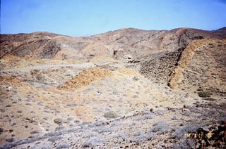
In the early 1970s Jay Todd, the managing editor of the Ensign, initiated a visit to the general areas where the Book of Mormon story began. He invited Lynn and Hope Hilton, who had extensive experience in the Middle East, to go to the Arabian Peninsula on behalf of the Ensign. Traveling with their daughter and with photographer Gerald W. Silver early in 1976, the Hiltons became the first Latter-day Saints to journey through western Saudi Arabia and, very briefly, southern Oman, examining possible routes that Lehi and his family may have used. What they saw and photographed established that parts of the southern coast of Oman had many of the features described by Nephi.2 Civil unrest in Oman continued to keep the country isolated, however, and another eleven years would pass before LDS researchers again visited southern Oman. In 1987 I visited the area for several days and made a more extensive examination of the Salalah area. That visit made it apparent that while Salalah met most of the requirements for Bountiful, as described in the Book of Mormon, the most important of these requirements—the natural vegetation, large trees, and fresh water—were found only several miles inland, separated from the ocean by an arid coastal plain. Yet the Book of Mormon description makes it appear that Nephi's Bountiful, where Lehi's group lived while they built and launched their ship, was right on the coast. Ruins of city ports dating to the first millennium BC showed that the coastline has not changed appreciably in thousands of years in the Salalah area, so these necessary elements were unlikely to have been any closer to the coast anciently. Those facts made it less likely that Salalah could qualify as a candidate for Bountiful, and a report that large trees were to be found on the coastline farther west near the Yemen border made it obvious that we needed to examine other sites before the matter was settled. In 1988 my wife and I began a four-year program of exploration, visiting in stages the remote coastal areas of Oman to the west of Salalah and also the entire eastern coastline of neighboring Yemen, which stretches more than 700 miles down to Aden at the southwestern corner of the Arabian Peninsula. This unprecedented land survey gave us basic information on the entire region and established, to our satisfaction, that no serious Bountiful candidates were to be found outside the southern Dhofar region of Oman. The survey also revealed that the most fertile places along this coastline lay within a small, little-known region of Oman backed by the Qamar mountains near the Yemen border. Unlike Salalah, this small region had places where extensive natural vegetation, including sizable trees, was found on the coast itself. This fertility is apparently due to the existence of small narrow valleys that funnel the annual monsoon rains inland, creating well-watered valleys. We soon discovered that here, as nowhere else, all the factors that Nephi mentioned were found in one place.3 Our interest soon focused on the greenest portion of this small region, the bay of Khor Kharfot ("Fort Inlet" or "Fort Port"). This unique spot is so isolated that even today it is almost unknown in other parts of Oman. It lies at the end of a long, narrow ravine, the Wadi Sayq ("River Valley"), that provides the only access from the interior desert to the coast through the Qamar mountains. In April and September 1993, two teams of specialists, including a geologist and an archaeologist, jointly sponsored by FARMS and Brigham Young University, visited Khor Kharfot for further examination. One of their first findings was that the place had once been a sheltered sea inlet until sometime in the last few hundred years when a beach was formed that closed off the bay. They also identified several distinct areas of ruins, indicating intermittent settlement at Kharfot over the centuries. What appear to be the oldest of these ruins were found on the small, flat western plateau overlooking the bay, but we will not know more about the ruins without excavation. Matching the Criteria for BountifulBefore we can be confident that Khor Kharfot or any other site is the most likely candidate for Bountiful, we must thoroughly examine the Book of Mormon text itself and construct a model from that data against which we can judge any real-world setting as a candidate.5 Almost casually woven into Nephi's seemingly sparse text is a wealth of detail about the lands he and his family passed through and especially about their point of departure for their epic sea journey. The direct statements of the Book of Mormon, combined with some logical conclusions drawn from them, allow us to establish a rather long list of characteristics about Old World Bountiful. Nephi's Bountiful was "nearly eastward" from NahomThis clear directional relationship between the two places (see 1 Nephi 17:1) was likely fairly precise, rather than just a general direction. In this Old World setting, Nephi was very precise about directions, recording earlier in his account, for example, that their travel from Jerusalem was in "nearly a south-southeast direction" (1 Nephi 16:13). Therefore, identifying the location of Nahom becomes important in the search for Bountiful. So far, only one site seems to meet the scriptural requirements for Nahom: the tribal area still known as Nehem which lies about twenty-five miles northeast of Sana'a, capital of the Republic of Yemen. Nehem is the only place in Arabia where the Semitic name nhm (spelled variously as Nahm, Nehem, Nihm, etc.) is preserved. The name has now been accounted for in the same location through maps and early writings to as early as AD 600 and possibly earlier. The location must be considered the leading candidate for Nahom. Nephi's account specifies that Ishmael was buried in "the place which was called Nahom" (1 Nephi 16:34). Nephi's phrasing suggests that Lehi's group did not originate the name but learned it from local inhabitants. Modern Nehem includes an extensive traditional burial area with tombs dating as far back as neolithic times, long predating Lehi's day. The roots of the name itself in Hebrew refers to mourning, consoling, and complaining of hunger, thus fitting perfectly the events recorded by Nephi after the death of his father-in-law, Ishmael (see 1 Nephi 16:35–39).6 Furthermore, the Jawf valley where Nehem is located marks the point where the ancient incense trade route, which runs parallel to the Red Sea coast of Arabia, turns east. Although the trade route again veers southward shortly after leaving Nehem, Lehi's group maintained their course "nearly eastward" from where they left the Nahom area until they reached Bountiful. An eastward course from Nehem would pass near the dreaded Empty Quarter of Arabia, which has virtually no sources of water. The aridity of the entire area might explain why Nephi's record suggests that this last stage of their desert travel was the hardest of all. Since Nehem lies at a latitude of about 16 degrees north, we should expect their trek "nearly eastward" to reach Bountiful close to the same latitude. Khor Kharfot lies at 16 degrees 45 minutes, or in other words less than one degree of deviation from true east over the nearly 600 miles of the last leg of their journey. Overland access to Bountiful was possible from the interior desertAccess to the southern coast from the interior of Oman is usually difficult and in some places impossible. Geologically separate from the rest of the southern region, the Qamar mountains hinder access to the small, most fertile region where we would expect Bountiful to be situated. However, a single route, the Wadi Sayq, leads through those mountains to the coast, offering a narrow, gradually descending pathway to the sea at Khor Kharfot. This narrow pass, scoured by millennia of annual flood runoff from the Qamar mountains through which it runs, offers the only direct overland route to the ocean from the interior along many miles of coastline. In addition to information from detailed satellite mapping, an examination in 1993 of Wadi Sayq from the very beginning of the valley confirmed that access from the inland desert was still feasible. Bountiful was fertileNephi describes Bountiful as yielding "meat" (perhaps small game that could be hunted), "much fruit," and "honey" (see 1 Nephi 17:5, 6; 18:6). Khor Kharfot is quite fertile. Trees grow naturally, some bearing fruit, and there are nesting birds, a variety of small animals, bees that provide wild honey, and abundant fish. Although the record does not say that the party grew crops from the seeds they brought from Jerusalem, the Kharfot area is sufficiently fertile to have supported such crops.

The area surrounding Bountiful was probably fertileNephi's use of the expression "the land of Bountiful" suggests that not only was the specific encampment fertile (see 1 Nephi 17:6), but the general area ("land") was also quite fertile (see 1 Nephi 17:5, 7). The Wadi Sayq/Khor Kharfot area lies at the eastern end of the most naturally fertile section of coastline on the whole coast of Arabia, a small strip only a few miles in length bounded by arid terrain on three sides and ocean on the fourth. Bountiful was suitable for a long encampment and for shipbuildingIt would likely have taken Nephi and his brothers at least a year to construct a ship substantial enough to carry perhaps thirty people two-thirds of the way around the globe. Thus the site for Bountiful must have been capable of sustaining a small colony for at least one and perhaps several years. Ruins at Khor Kharfot, which have yet to be excavated, appear to indicate that at least one small community lived there for some time. For several months each year during the monsoon, heavy seas, fog, and rain envelope the southern Arabian coastline, making outdoor activities like shipbuilding difficult. Presumably Nephi and his brothers stopped work on the ship during this period of the year or Bountiful offered enough shelter to allow them to continue. At Kharfot, a small plateau of higher ground overlooks the western side of the bay, and it might have provided a suitable site for work in bad weather. The ruins on this plateau appear to be the oldest at Kharfot. Timber was readily availableTo build his ship, Nephi would have needed access to sufficient timber of the right types and sizes to fashion a seaworthy vessel (see 1 Nephi 18:1, 2, 6). Moving timber to the shore would have been a time-consuming and arduous task, so it is likely that trees were available very near the coast; this is probably part of what Nephi meant by "Bountiful." Numerous large trees are still found at Khor Kharfot almost down to the ocean, and they were certainly even more plentiful in the past. (Drought in recent centuries has reduced the natural forests that formerly covered the sides of the valley and the surrounding mountains.) Timber from several species identified at Kharfot—particularly the sycamore fig (Ficus sycamorus) and the tamarind (Tamarindus indica)—would have been suitable for building a seagoing craft. Of course we can only speculate on the type of vessel that Nephi constructed. Arabia is the birthplace of the well-known "sewn" boats—vessels stitched together using tough cord without nails or other metal—but we have no way of knowing if Nephi used this method of shipbuilding. Nephi emphasized the fact that neither the preparation of the timbers nor the construction method were "after the manner of men" (1 Nephi 18:2) and that revelation from the Lord was necessary on a regular basis as construction proceeded (see 1 Nephi 18:1, 3). But we know wood was used, since Nephi mentions "timbers" repeatedly.

A year-round supply of freshwater must have been available for the campKharfot contains the largest source of freshwater on the Arabian coast, and there is evidence that water was even more abundant in ages past. By comparison, eastern Yemen has only three small and irregular streams of coastal water in its 700-mile length, yet in the Dhofar province of Oman alone, small streams and springs are found at Rakhyut a few miles east of Kharfot and in the Salalah foothills, in addition to Wadi Sayq. Bountiful had a prominent mountainA mountain prominence that Nephi referred to as "the mount" (1 Nephi 17:7; 18:3) was close enough to the campsite that he could go there to "pray oft" (1 Nephi 18:3). Nephi's choice of words indicates that he was referring to an isolated and prominent mountain rather than a mountain range. Fittingly, at Kharfot the highest and most prominent peak is isolated directly above the little western plateau where evidence of former settlement is most abundant and on which Lehi's family would have been most likely to camp. Bountiful probably had cliffs overlooking the oceanLaman and Lemuel attempted to kill Nephi by throwing him into the sea (see 1 Nephi 17:48). This seems to imply cliffs overlooking the ocean, since Nephi's life would not have been threatened by being thrown into the ocean from a beach. At Khor Kharfot, dangerous cliffs averaging 200 feet high overlook the ocean at the edge of the elevated western plateau.

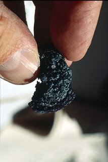 |
| Iron ore produced by scientiest |
Bountiful had a source of oreOre from which metal could be smelted for making tools must have been available near enough to the camp that Nephi could be shown where to find it without unusual effort, along with flint to start a fire (see 1 Nephi 17:9–11, 16). Oman has a history of copper smelting over several thousand years, but the primary known deposits are in the northern half of the country. However, a recent FARMS-sponsored survey of the area surrounding Kharfot revealed numerous small sources of specular hematite that could yield iron suitable for making shipbuilding tools.7 The same general area, only a few miles inland from the coast, also has unusually extensive surface deposits of chert, a form of flint useful for starting fire. This distance from the coast would not have posed the same problem with ore that it likely would have with timber, since only small quantities of ore would have been necessary, as opposed to large quantities of timber. It seems unlikely that Bountiful was inhabited by other groups at this timeThe Book of Mormon mentions no interaction with other groups at Bountiful. Had such groups existed, Nephi probably would not have needed specific divine revelation on where to go to obtain ore for making tools or perhaps on how to construct the ship, since he might have gathered this information from other residents. So Bountiful probably had no resident population during the period that Nephi constructed the ship. This seclusion may have been important to keep Lehi's group uncontaminated from the polytheistic beliefs then common throughout Arabia and to insulate them from the diversions and enticements of the trading ports.
No comments:
Post a Comment