Blog Archive

28 September 2006

land of Bountiful, as described in the Book of Mormon.


The land of Bountiful

Several authors have suggested possible locations for the land of Bountiful, as described in the Book of Mormon.

Lynn M and Hope A. Hilton focused on the inlet bay at Salalah, the ancient al-Balīd.  This inlet bay — called a Khor in the local Arabic dialect — exhibits attractive features that would support an identification of Bountiful with this area.

Warren and Michaela Aston, on the other hand, were able to explore farther afield because the military conflict that limited Lynn Hilton's travel in southern Oman in 1976 had ended by the time the Astons came to Oman in the early 1990s. After an on-site review of inlet bays and verdant areas along the south coast of Arabia, the Astons settled on the Wadi Sayq (Khor Kharfot) as the spot which they felt most fully met the requirements for Bountiful as Nephi's narrative photograph hints at them.

Though these two sites — al-Balīd and Wadi Sayq — possess remarkable features that could connect them with Bountiful, there is another. In our view, this other inlet bay, named Khor Rori, offers a dimension that the other two do not, the three maritime resources that Nephi would have needed to reach the Promised Land:


The raw materials necessary to actually build an ocean-going ship,A reasonably large natural harbor where Nephi and his brothers could construct, launch and moor their ship, an.The means by which Nephi could learn to sail such a vessel.
Without all three of these resources, Nephi could not have made his journey. For any site to qualify as a candidate for Bountiful, it must have possessed these characteristics during his era. We propose that there is a growing body of evidence that suggests that the ancient frankincense port of Khor Rori possessed the unique maritime resources needed by Nephi, as well as all the other attributes mentioned in his record.

Khor Rori lies in the same fertile plain that Hugh Nibley and the Hiltons suggest was probably Bountiful. Today, large fruit plantations are found along the beach at Taqah, just two miles from the Khor.

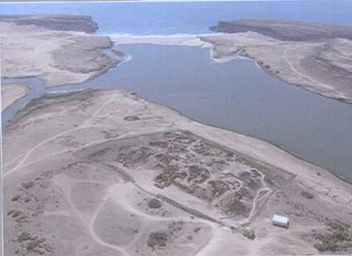
The inlet was the premier port of Dhofar and is generally regarded as the port known to the Greeks as Moscha. It is a large waterway extending more than 1½ miles inland. The Khor has several natural places where ships could moor, making it the likely reason that Khor Rori and the adjacent town of Taqah were called Merbat (the moorings) anciently.

The Khor is fed by freshwater from Wadi Dharbat, a large natural spillway carrying rainwater from the Jabal Samhan mountains. Frankincense grew on the hills of Dhofar and was harvested by the local people in antiquity, the ‘Adites. Frankincense is a sweet smelling gum made from the sap of the Frankincense tree (Boswelia sacra). It was highly prized and used in temple ceremonies in Egypt, Mesopotamia, Greece, Rome and Israel from very early times.

On the slopes of the mountains overlooking the plain of Dhofar, the ”Adites built a large settlement set on the banks of what were once three converging streams. This site, called Hagif #240 by archeologists, is the largest Bronze Age” site in all Oman site and stretched over three miles. Adites artifacts are found at Khor Rori.

A native population at Bountiful is consistent with Nephi’s description of it being outside of the wilderness (1 Nephi 17:4, 5). Also in harmony with Nephi’s Bountiful, the Adites cultivated gardens and orchards, and legend holds that they ate fruit at every meal. Later, in the Iron Age, the “Adites built settlements inland at Shisr and near the coast at Ain Humran to enable them to control the trade by land and by sea.” In order to gain control of the frankincense trade, this area was invaded around the time of Christ by King ”Il'ad Yalut, king of Hadramaut, who established an impressive port city named Samhuram — meaning ‘the plan is great’ or ‘the great scheme.’”

Today there is a sandbank across the Khor, closing it off from the sea. This was not always present, however. Scientists believe that a drop in the sea levels around the 14th-15th centuries A.D. caused the closure of the harbor’s mouth. Radiocarbon dating establishes that there was a stable and final closure occurring around 1640-1690 A.D. Huge cliffs line the sea entrance to Khor Rori forming natural breakwaters that allowed ancient ships to sail out 200 yards into the Indian Ocean proper with protection from the surf. This was the great strength of Khor Rori as a port; the natural breakwater provided protection from both the summer southwest monsoon and the winter northeast monsoon winds. Thus the port could be used all year for shipping and shipbuilding.

In Part Two in this series, we will examine the specific resources Nephi required to build his ship. In Part Three we will explain why these resources where found only at Khor Rori in Nephi’s time, and thus provide an explanation as to why the Lord had Lehi travel 2100 miles across the hellish desert of Arabia in order to build his ship.


The story of Noah and his family being spared from a world- wide deluge (a judgment by God) is one of the most important in the Old Testament. Much is learned about the nature of God from this story. For example:
 (1) It shows He is a holy God and cannot tolerate sin. 
(2) It shows He is a just God and that sin will not go unpunished.
 (3) It shows He is a God of mercy in that He spares some. 
(4) It shows God's power in that the Flood unleashed great power.


Khor Rori


Evidence root


Substantial new evidence identifies a lush area in the western corner of Oman as the possible location where Nephi built the ship that carried Lehi's family to the promised land.

Most Book of Mormon scholars agree that Lehi took his family south out of Jerusalem, down the Arabah and south to somewhere near Aqaba. From there Lehi angled on a southeastly direction paralleling the Red Sea coast of Saudi Arabia. Lehi's journey likely took them through or near Medina and Mecca, two holy cities of present day Islam. About 300 miles south of present day Mecca is an oasis called Al Kunfadah, the place Lehi called Nahom, the place where Ishmael died and was buried. From here Lehi turned nearly due east and crossed the lower portion of one of the most barren deserts in the world (The Empty Quarter).

The route Lehi took paralleled the ancient Frankincense Trail. Frankincense is a vegetable resin from the Boswellia, a family of decidious shrubs or trees found in northeast Africa. The resin hardens when dried, into small yellow grains, which are then burned for their aromatic quality. It is called "frank" because of the freeness with which it gives forth its odor. The resin is often burned as incense, used as a fragrance or as an embalming agent. Frankincense came, anciently, primarily from Sada, Yemen (northeast of San'a, Yemen). San'a, anciently, was the terminal point of the Frankincense Trail, a well known and much travelled trade route between San'a, Yemen and Sidon, Lebanon. But the trail continued east from San'a, though much less travelled. Lehi likely followed, or paralleled, this trail to somewhere near Salala, Oman.

Travelling nearly a thousand miles across southern Saudi Arabia, Lehi arrived at a place he called "Bountiful". Lehi describes this area as a place of "much fruit and also wild honey...and we called the place Bountiful, because of its much fruit." This is a startling declaration considering Arabia was a place known for its barrenness, its desolation, and for its lack of trees. Indeed, according to Hugh Nibley, "The best guide to Arabia at the time...imagined forests and lakes in the center of the peninsula, while insisting that the whole coastline was 'a rocky wall...as dismal and barren as can be: not a blade of grass or a green thing' to be found." It was no surprise that critics in Joseph Smith's day hooted at this story.

Even after Europeans explored the real Arabia and discovered that it truly was a barren, desolate desert; where could possibly be the forested area Nephi used to build his ship? The very idea was preposterous. The area described in 1 Nephi had to meet several conditions: 
1) timber adequate for building a large sea going vessel, 
2) iron ore in nearby mountains for fashioning steel tools and instruments, 
3) high cliffs above the sea, 
4) fruit trees, 
5) fresh water, 
6) animals that provided meat. 
All of these seem incongruent with contemporary knowledge of the Arabian peninusla.

There have been few who have actually travelled to Saudi Arabia to attempt to find a place that could possibly meet all these criteria. Bertram Thomas did so in 1928, the Hiltons in the 1970s, two Australians, Warren and Michaela Aston, in 1992, and finally Maurine and Scot Proctor. As expected from the various reports over the years since Bertram Thomas, Arabia does have a tiny stretch of verdant coastline, made green by the monsoons that pelt this corner of the land and nowhere else. This forest is Arabia's surprise, an anomaly in a land of sand and mountains like the moon.

But the Astons wanted more. They wanted to test the land against Nephi's description to see if any specific location matched. Nephi gave us many specific clues about his Bountiful. Clearly, it was coastal, accessible from the interior along a reasonable route. What's more, it was fertile, a place of "much fruit" and honey where the group could grow crops to maintain themselves as they built a ship. For a place to qualify as Bountiful, it had to have timber in enough types and sizes to permit ship building and a mountain prominent enough to be called "the mount," close enough that Nephi could retreat there and "pray oft."

Bountiful also had to have ore from which metal could be smelted, a source to make fire, and probably a cliff by the sea where Laman and Lemuel could have made good their promise to throw Nephi into the deep. With this comprehensive set of clues, the Astons combed the coast and seriously considered six areas as candidates for Bountiful. Only one of the six was a fit, a tiny beach only a kilometer and a half wide called Wadi Sayq, nearly on the border between Oman and Yemen.

On either side of the beach are 2,500-foot cliffs that drop straight into the sea, making access impossible along the shore, but the wadi (like a dry river bed) cuts its way 15 miles through a steep canyon into the interior. This is the beach's only entrance, difficult enough to travel that even though the beach basks glorious and green in tropical sunlight Wadi Sayq is remote and forgotten. To this day it is uninhabited.

Was this the place where Nephi built the ship? The Astons were compelled enough by the match between Wadi Sayq and Nephi's description of Bountiful that they published a paper detailing their research for FARMS, the Foundation for Ancient & Mormon Studies ("And We Called the Place Bountiful: The End of Lehi's Arabian Journey").

Another couple who visited the area is Maurine and Scot Proctor who rented a Jeep in Salala, about eighty miles east of Wadi Sayq, and drove west toward the location they believed best fit the description of Bountiful. Wadi Sayq drops off the western plateau at about the 4,000 foot elevation. From here the wadi drops four thousand feet in sixteen miles to the coast. The wadi is barren and desolate and gives no hint of its lush ending near the sea. The only practical access is from the sea, by boat.

Wadi Sayq is one of two "rivers" in Arabia that flow near the shore with water all year round. Trees abound with "much fruit" available in the form of date-palm fruit. Dolphins frolic in the waters near the beach, wild flamingos wade in the fresh water. This is a place that perfectly matched Nephi's description. A free-standing mountain occupied the southwest of the beach. Towering tarmarind and sycamore trees suitable for shipbuilding grew up in the wadi a few hundred yards away from shore. Here was a freshwater source, sardine in the sea for eating, land and water to grow crops.

Large sycamore, tarmarind, and boscia trees, 60 to 80 feet high, grow in abundance about a half mile from the beach at Wadi Sayq. Sycamores are excellent shipbuilding lumber and could have supplied Nephi with the lumber for his ship

The Astons had written that they had found archaeological remains in Wadi Sayq, signs of former human habitation. They reported that on the east side of the wadi stood a mound some twelve feet high and forty-five feet in diameter, now covered with wind-blown sand and vegetation. Radiating from this mound, they noted, were double lines of stones. One of them stretched about ninety feet toward the beach. A second double line of stones, some 400 feet long, curved back toward the freshwater of the wadi. They also reported a rock face, not far from the mound that contained several groups of graffiti. Though some of the graffiti looked relatively recent, sketched on the rock was what appeared to be a much older set of graffiti, its red pigment faded with time. Painted in that faded red on the rock was a ship.

The Proctors began their exploration of the wadi on the opposite side from the mounds, they started to see double lines of stones everywhere. One line over 600 feet long stretched perpendicular from the beach, back into the trees. Another at right angles to it ran across the valley. Who had built these double lines, and for what purpose? Further down the wadi, a foundation was visible. Not far away were several three-feet high stone structures shaped like an omega. A little farther, we saw the remains of an ancient well.

The oval mound observed by the Proctors in their visit to Wadi Sayq. Was this the construction site for Nephi's ship?

Later, the Proctors observed an oval rock pattern outline on the beach in the exact shape of a ship. It measured 130 feet long by 65 feet wide. At each end and in the middle of the pattern was a large buildup of rocks. Could these have been the supports for the scaffolding of a ship? Curiously, here, in this oval shape, the vegetation grew more densely. Piles of rocks could be seen leading in succession to the high-water tide line of the ocean, perhaps used as supports for a launching ramp.

Not far from here was a large, concave, half-moon-shaped rock with an air shaft that ran completely underneath. Observing the traces of carbon built up on the rock face, they wondered if this might be a candidate for a foundry. The rock, the mound, and the oval shape of a ship were all proximate to each other. It's possible the double line of rocks from the fresh water to the mound was used to bring water to run some kind of waterworks, if the mound might have once been some kind of pully system used to build a ship.

It is not known who built these structures, they have not been dated, and it is impossible to say what they were used for. But it is no longer possible to ridicule the Book of Mormon story of Lehi's crossing of a barren desert and his climactic landing on a lush, forested, protected beach that meets all the conditions required by the story.

Final Resting Place of Noah's Ark:

The Bible says in Gen. 8:4 that the Ark came to rest on the mountains (plural) of Ararat. At the time Moses wrote Genesis Ararat was a mountainous region located in what is today Eastern Turkey. The Bible only gives a general location for the final resting place of Noah's Ark. Contrary to what many Christians believe, the Bible does not say the Ark landed on the Mt. Ararat of today. There is, however, compelling evidence from ancient history that the Ark landed on a mountain about 200 miles south of Mt. Ararat. Josephus seems to be referring to this mountain, and he claims it still existed in his day. An Arabic historian says the last remains of the Ark were hauled away about 1000 A.D.

A group of Chinese and Turkish evangelical explorers say wooden remains they have discovered on Mount Ararat in eastern Turkey are the remains of Noah's Ark. 

The group claims that carbon dating proves the relics are 4,800 years old, meaning they date to around the same time the ark was said to be afloat. Mt. Ararat has long been suspected as the final resting place of the craft by evangelicals and literalists hoping to validate biblical stories


Read more: http://www.foxnews.com/scitech/2010/04/27/noahs-ark-found-turkey-ararat/#ixzz1S4gg2A9Y


Useful Links :

Where Did Nephi Build His Ship?


Substantial new evidence identifies a lush area in the western corner of Oman as the possible location where Nephi built the ship that carried Lehi's family to the promised land.

Most Book of Mormon scholars agree that Lehi took his family south out of Jerusalem, down the Arabah and south to somewhere near Aqaba. From there Lehi angled on a southeastly direction paralleling the Red Sea coast of Saudi Arabia. Lehi's journey likely took them through or near Medina and Mecca, two holy cities of present day Islam. About 300 miles south of present day Mecca is an oasis called Al Kunfadah, the place Lehi called Nahom, the place where Ishmael died and was buried. From here Lehi turned nearly due east and crossed the lower portion of one of the most barren deserts in the world (The Empty Quarter).
The route Lehi took paralleled the ancient Frankincense Trail. Frankincense is a vegetable resin from the Boswellia, a family of decidious shrubs or trees found in northeast Africa. The resin hardens when dried, into small yellow grains, which are then burned for their aromatic quality. It is called "frank" because of the freeness with which it gives forth its odor. The resin is often burned as incense, used as a fragrance or as an embalming agent. Frankincense came, anciently, primarily from Sada, Yemen (northeast of San'a, Yemen). San'a, anciently, was the terminal point of the Frankincense Trail, a well known and much travelled trade route between San'a, Yemen and Sidon, Lebanon. But the trail continued east from San'a, though much less travelled. Lehi likely followed, or paralleled, this trail to somewhere near Salala, Oman.
Travelling nearly a thousand miles across southern Saudi Arabia, Lehi arrived at a place he called "Bountiful". Lehi describes this area as a place of "much fruit and also wild honey...and we called the place Bountiful, because of its much fruit." This is a startling declaration considering Arabia was a place known for its barrenness, its desolation, and for its lack of trees. Indeed, according to Hugh Nibley, "The best guide to Arabia at the time...imagined forests and lakes in the center of the peninsula, while insisting that the whole coastline was 'a rocky wall...as dismal and barren as can be: not a blade of grass or a green thing' to be found." It was no surprise that critics in Joseph Smith's day hooted at this story.
Even after Europeans explored the real Arabia and discovered that it truly was a barren, desolate desert; where could possibly be the forested area Nephi used to build his ship? The very idea was preposterous. The area described in 1 Nephi had to meet several conditions: 1) timber adequate for building a large sea going vessel, 2) iron ore in nearby mountains for fashioning steel tools and instruments, 3) high cliffs above the sea, 4) fruit trees, 5) fresh water, 6) animals that provided meat. All of these seem incongruent with contemporary knowledge of the Arabian peninusla.
There have been few who have actually travelled to Saudi Arabia to attempt to find a place that could possibly meet all these criteria. Bertram Thomas did so in 1928, the Hiltons in the 1970s, two Australians, Warren and Michaela Aston, in 1992, and finally Maurine and Scot Proctor. As expected from the various reports over the years since Bertram Thomas, Arabia does have a tiny stretch of verdant coastline, made green by the monsoons that pelt this corner of the land and nowhere else. This forest is Arabia's surprise, an anomaly in a land of sand and mountains like the moon.
But the Astons wanted more. They wanted to test the land against Nephi's description to see if any specific location matched. Nephi gave us many specific clues about his Bountiful. Clearly, it was coastal, accessible from the interior along a reasonable route. What's more, it was fertile, a place of "much fruit" and honey where the group could grow crops to maintain themselves as they built a ship. For a place to qualify as Bountiful, it had to have timber in enough types and sizes to permit ship building and a mountain prominent enough to be called "the mount," close enough that Nephi could retreat there and "pray oft."
Bountiful also had to have ore from which metal could be smelted, a source to make fire, and probably a cliff by the sea where Laman and Lemuel could have made good their promise to throw Nephi into the deep. With this comprehensive set of clues, the Astons combed the coast and seriously considered six areas as candidates for Bountiful. Only one of the six was a fit, a tiny beach only a kilometer and a half wide called Wadi Sayq, nearly on the border between Oman and Yemen.
On either side of the beach are 2,500-foot cliffs that drop straight into the sea, making access impossible along the shore, but the wadi (like a dry river bed) cuts its way 15 miles through a steep canyon into the interior. This is the beach's only entrance, difficult enough to travel that even though the beach basks glorious and green in tropical sunlight Wadi Sayq is remote and forgotten. To this day it is uninhabited.
Was this the place where Nephi built the ship? The Astons were compelled enough by the match between Wadi Sayq and Nephi's description of Bountiful that they published a paper detailing their research for FARMS, the Foundation for Ancient & Mormon Studies ("And We Called the Place Bountiful: The End of Lehi's Arabian Journey").
Another couple who visited the area is Maurine and Scot Proctor who rented a Jeep in Salala, about eighty miles east of Wadi Sayq, and drove west toward the location they believed best fit the description of Bountiful. Wadi Sayq drops off the western plateau at about the 4,000 foot elevation. From here the wadi drops four thousand feet in sixteen miles to the coast. The wadi is barren and desolate and gives no hint of its lush ending near the sea. The only practical access is from the sea, by boat.
Wadi Sayq is one of two "rivers" in Arabia that flow near the shore with water all year round. Trees abound with "much fruit" available in the form of date-palm fruit. Dolphins frolic in the waters near the beach, wild flamingos wade in the fresh water. This is a place that perfectly matched Nephi's description. A free-standing mountain occupied the southwest of the beach. Towering tarmarind and sycamore trees suitable for shipbuilding grew up in the wadi a few hundred yards away from shore. Here was a freshwater source, sardine in the sea for eating, land and water to grow crops.

Large sycamore, tarmarind, and boscia trees, 60 to 80 feet high, grow in abundance about a half mile from the beach at Wadi Sayq. Sycamores are excellent shipbuilding lumber and could have supplied Nephi with the lumber for his ship

The Astons had written that they had found archaeological remains in Wadi Sayq, signs of former human habitation. They reported that on the east side of the wadi stood a mound some twelve feet high and forty-five feet in diameter, now covered with wind-blown sand and vegetation. Radiating from this mound, they noted, were double lines of stones. One of them stretched about ninety feet toward the beach. A second double line of stones, some 400 feet long, curved back toward the freshwater of the wadi. They also reported a rock face, not far from the mound that contained several groups of graffiti. Though some of the graffiti looked relatively recent, sketched on the rock was what appeared to be a much older set of graffiti, its red pigment faded with time. Painted in that faded red on the rock was a ship.
The Proctors began their exploration of the wadi on the opposite side from the mounds, they started to see double lines of stones everywhere. One line over 600 feet long stretched perpendicular from the beach, back into the trees. Another at right angles to it ran across the valley. Who had built these double lines, and for what purpose? Further down the wadi, a foundation was visible. Not far away were several three-feet high stone structures shaped like an omega. A little farther, we saw the remains of an ancient well.
The oval mound observed by the Proctors in their visit to Wadi Sayq. Was this the construction site for Nephi's ship?

Later, the Proctors observed an oval rock pattern outline on the beach in the exact shape of a ship. It measured 130 feet long by 65 feet wide. At each end and in the middle of the pattern was a large buildup of rocks. Could these have been the supports for the scaffolding of a ship? Curiously, here, in this oval shape, the vegetation grew more densely. Piles of rocks could be seen leading in succession to the high-water tide line of the ocean, perhaps used as supports for a launching ramp.
Not far from here was a large, concave, half-moon-shaped rock with an air shaft that ran completely underneath. Observing the traces of carbon built up on the rock face, they wondered if this might be a candidate for a foundry. The rock, the mound, and the oval shape of a ship were all proximate to each other. It's possible the double line of rocks from the fresh water to the mound was used to bring water to run some kind of waterworks, if the mound might have once been some kind of pully system used to build a ship.
It is not known who built these structures, they have not been dated, and it is impossible to say what they were used for. But it is no longer possible to ridicule the Book of Mormon story of Lehi's crossing of a barren desert and his climactic landing on a lush, forested, protected beach that meets all the conditions required by the story.


The discovery of Ubar (Iram)

UBAR- The Lost City of Iram of Pillars

Atlantis of the Sands
Atlantis of the Sands is the fictional name of a legendary lost city in the southern Arabian sands, claimed to have been destroyed by a natural disaster or as a punishment by God. The search for it was popularized by the 1992 book Atlantis of the Sands


Location: Shisr, off Route 31 from Thumrayt 
For more information: 800 777999; www.omantourism.gov.om

About The Lost City of Iram of Pillars : Ubar, a name of a region or a name of a people, was mentioned in ancient records, and was spoken of in folk tales as a trading center of the Rub Al-Kali desert in the southern part of the Arabian peninsula. It is estimated that it lasted from about 3000 BC to the 1st century AD. According to legends, it became fabulously wealthy from trade between the coastal regions and the population centers of the Arabic peninsula and Europe. The region became lost to modern history, and was thought to be only a figment of mythical tales. Some confusion exists about the word "Ubar". In classical texts and Arabic historical sources, Ubar refers to a region and a group of people, not to a specific town. Ptolemy's 2nd century map of the area shows "Iobaritae". It was only the late Medieval version of The One Thousand and One Nights, in the fourteenth or 15th century, that romanticized Ubar and turned it into a city, rather than a region or a people.


The Qur'an (1,400 years ago) mentions a certain city by the name of Iram (a city of pillars) [Qur'an: The Dawn 89:7], which was apparently not known in ancient history and non-existent as far as historians were concerned. But the December 1978 edition of the National Geographic Magazine records that in 1973, the city of Ebla was excavated in Syria. The city was discovered to be 4,300 years old. Researchers found in the library of Ebla a record of all of the cities with which Ebla had done business. On the list was the specific name of the city of "Iram" (and not the name of the general region of Ubar). The people of Ebla had apparently done business with the people of "Iram"


FABLED CITY
Certainly the myths surrounding Ubar were unparalleled - even by "lost city" standards. According to legend Ubar was a magnificent kingdom, rich beyond measure -the original city of "streets paved with gold." Indeed it is described in the Holy Quran as "the many-columned city whose like has not been built in the whole land."It was here, archaeologists believe, that great caravans were assembled for the transport of frankincense across the desert. But it's great wealth built on the frankincense trade -also proved its downfall.Corrupted by riches, Ubar was said to have become a hotbed of wickedness - and like Sodom and Gomorrah -suffered the wrath of God. Historians chronicle Ubar's destruction somewhere between the first and fourth centuries AD.Thus Ubar was, quite literally, swallowed up by the desert - passing into legend as the Atlantis of the Sands and becoming the most fabled city in all Arabia. Over the centuries which followed, explorers and historians searched unsuccessfully for the lost city and doubts grew whether Ubar had ever really existed.Clapp was no explorer. But, as a documentary filmmaker, he knew how to check facts. And the fact was that generations of "Ubar hunters" had been thrown off the track by a simple slip of the pen in the 15th century! In 1460 a monk had "misplaced" Ubar by hundreds of miles - baffling scholars and archaeologists for centuries thereafter:Luckily, by the time Clapp became hooked in the legend of Ubar, there was more at his disposal than ancient manuscripts and the often-unreliable etchings of mediaeval monks.But even he, at the beginning of his quest, could never have imagined that the Atlantis of Arabia, the buried city of Ubar, would be unearthed from Outer Space.
COLORFUL CLUES TO DISCOVERY
It may look like a weird and colorful painting to a layman but to the scientists this image taken from space is further confirmation of the site of the lost city of Ubar. It is a radar image of the region around the site of the lost city in southern Oman, originally discovered from space in 1992. This image was acquired on orbit 65 of the NASA Space Shuttle Endeavour in 1994 by imaging radar and covers an area about 50 by 100 kilometres of the Arabian Peninsula.The prominent magenta colored area is a region of large sand dunes. The prominent green areas are rough lime stone rocks that form a rocky desert floor. A major wadi, or dry streambed, runs across the middle and is shown largely in white. The fortress of the lost city of Ubar is near the wadi, close to the center of the image. The fortress is too small to be detected but tracks leading to the site appear as prominent reddish streaks. These tracks have been used in modern times but field investigation showed many were in use in ancient times as well
Evidence The Lost City of Iram of Pillars:

Recent discoveries have brought Iram out of the realm of fable and into history.
In the early 1980s a group of researchers interested in the history of Iram used NASA remote sensing satellites, ground penetrating radar,Landsat program data and images taken from the Space Shuttle Challenger as well as SPOT data to identify old camel train routes and points where they converged. These roads were used as frankincense trade routes around 2800 BC to 100 BC.
One area in the Dhofar province of Oman was identified as a possible location for an outpost of the lost civilization. A team including adventurer Ranulph Fiennes, archaeologist Juris Zarins, filmmaker Nicholas Clapp, and lawyer George Hedges, scouted the area on several trips, and stopped at a water well called Ash Shisar.[3] Near this oasis was located a site previously identified as the 16th century Shis'r fort. Excavations uncovered an older settlement, and artifacts traded from far and wide were found. This older fort was found to have been built on top of a large limestone cavern which would have served as the water source for the fort, making it an important oasis on the trade route to Iram. As the residents of the fort consumed the water from underground, the water table fell, leaving the limestone roof and walls of the cavern dry. Without the support of the water, the cavern would have been in danger of collapse, and it seems to have done so some time between 300-500 AD, destroying the oasis and covering over the water source.
Four subsequent excavations were conducted by Dr. Juris Zarins, tracing the historical presence by the people of 'Ad, the assumed ancestral builders of Iram
Atlantis of the Sands is the popular name given to a legendary city in southern Arabia believed to have been destroyed by a natural disaster or act of God.The Holy Qurân's description of Ubar as 'asdhat ai-imad' - "city of lofty pillars" - was mirrored in the towers of the discovered city. And these towers guarded a water source that more than anything else in the surrounding 50,000 square miles qualified as the "great well of Wabar."For all its isolation here was a place where, as in legend, people prospered and lived well, cooking and dining on the ware of classical civilizations.Last, the legend of Ubar surfaced when the city sank into the sands. And this city collapsed into an underground cavern. Of all the sites in all the ancient world, Ubar came to a unique and peculiar end -an end identical in myth and now, it transpired, in reality.There was no question. This was Ubar -the Atlantis of the Sands. As Clapp says: "Before the discovery, all that was known of Ubar was its myth and legend and that there was a road out in the desert that just might lead to the lost city."The lore of Ubar proved to be a striking match for its reality. Ubar was in the right place, it was of the right age, and it had been destroyed exactly as the myth had described."But perhaps the single most amazing thing about the lost city of Ubar is the way it was found the technology of the future literally unearthing the secrets of the past.As Blom put it following the discovery: "People have written about Ubar for thousands of years, and they hunted for it in the desert all through this century without any luck. And we cracked the case sitting here in Pasadena.


The satellite photographs show a section of Oman in the south of the Arabian Peninsula. In the photographs of the city of Ubar, viewed from space by NASA in 1992, were identified traces of ancient desert tracks. The people of ‘Ad, revealed 1,400 years ago in the Qur’an, emerged as one of the miracles of the Qur’an through modern-day technology

The discovery of Ubar (Iram) made world headlines in 1992, “Fabled Lost Arabian city found”, “Arabian city of Legend found”, “The Atlantis of the Sands, Ubar”. Ubar was truly legendary, described in the Qur'an as:
Seest thou not how thy Lord dealt with the 'Ad (people),-Of the (city of) Iram, with lofty pillars, The like of which were not produced in (all) the land? (Surat al-Fajr: 6-8)The discovery can be attributed to the persistence of Nicholas Clapp and Ranulph Fiennes, both adventurers / amateur archaeologists, who tracked down this legendary city mentioned in the Qur’an. They were led to Ubar by the book 'Arabia Felix' by desert adventurer Bertram Thomas, the first European that crossed the Rub Al Khali, the un-impregnable vast sand desert that covers most of the southern part of the Arabian Peninsula.. During his travels Thomas noticed that the tribes living in the region of the Dhofar mountains in South Oman considered themselves the descendants of the "People of 'Ad", the people that were associated in the Qur'an with Ubar. When making his famous crossing of 'The Sands' he came across ancients caravan tracks at approximately 18°45'N -52°30'E that were explained by his Arab guides as 'the road to Ubar'.
Clapp got fascinated by the Ubar story and started reading everything he could lay his hands on. Fiennes had been stationed in Oman in his military time and had roamed around in southern Oman extensively, with the lost city always in the back of his mind . Both homed in on southern Oman and decided to find Thomas' tracks, reasoning that all roads must lead somewhere. They got help from space technology, with NASA shuttle space images revealing pieces of the ancient tracks and converging to the small oasis settlement of Shisur, which is now identified as Ubar. Ironically they, like Thomas long before them, visited Shisur during reconnaissance expeditions exploring the Rub Al Khali to the west, expecting to find the desert city hidden in the vast dune areas to the west. Only after failing to find anything in the sands Clapp's team realised in 1990 that the unimpressive ruined fort at Shisur may be older than originally assumed and that it was actually situated right at the point of convergence of many old caravan tracks. Clapp's famous book (see references) may therefore be better called 'the road from Ubar'.The image is acquired on orbit 65 of space shuttle Endeavor on April 13, 1994 by the Spaceborne Imaging Radar C/X-Band Synthetic Aperture Radar (SIR-C/X-SAR). The SIR-C image shown is centered at 18.4 degrees north latitude and 53.6 degrees east longitude. The image covers an area about 50 by 100 kilometers (31 miles by 62 miles). The image is constructed from three of the available SIR-C channels and displays L- band, HH (horizontal transmit and receive) data as red, C- band HH as blue, and L-band HV (horizontal transmit, vertical receive) as green. The prominent magenta colored area is a region of large sand dunes, which are bright reflectors at both L- and C-band. The prominent green areas (L-HV) are rough limestone rocks, which form a rocky desert floor. A major wadi, or dry stream bed, runs across the middle of the image and is shown largely in white due to strong radar scattering in all channels displayed (L and C HH, L-HV). The actual site of the fortress of the lost city of Ubar, currently under excavation, is near the Wadi close to the center of the image. .
For description see above and Nasa Website, notice the modern and ancient tracks converging on Sishur, just left below the centre of the images and from there heading to the northwest into the Rub Al Khali
Excavations at Sishur revealed a sizeable walled fortress that had partly collapsed in a large sinkhole. Before collapsing, the sinkhole must have been a large cave partly filled with water and probably with a well on top allowing access to the all important water. It had clearly collapsed after the fortress was built, taking down almost the full interior space of the fortress and a sizeable part of the gate and adjacent walls.Originally the fortress had eight or more towers, connected by a 2.5 to 3 metres high wall and almost one metre thickness, built of local limestone. The main internal building was in the northwestern corner of the fortress. The Qur'an tells us of ' a city with lofty buildings, which the excavations surely revealed. The towers guarded the most important source of water before the Rub Al Khali, now hidden in the collapsed sinkhole. To link this source with the 'great well of Wabar' that according to the Arabic historian Yacut ibn Abdallah was the main feature in the city of Ubar does not need much imagination.The legend of Ubar tells us that God punished the people of 'Ad, for wasting their wealthy sinful lives and not listening to his warnings, a story not unlike Sodom and Gomora in the Bible. He destroyed these people by 'sinking them in the sand', which is what clearly happened at Shisur.Studies since the early 1990's, mainly led by Juris Zarins, the archeologist that was part of Clapp's original team, indicate that Ubar refers to a region and a group of people, not to a specific town. Ptolomy's second century map of the area clearly labels "Iobaritae". There was a tribal group of people, the Iobaritae or the Ubarites, who lived in the area, and the Shisur site is one of probably three or four major centers from that period. Whether it is Ubar or not is irrelevant from that perspective as it was clearly a key site along the incense caravan route at the edge of the great Empty Quarter.
The Ubarites and FrankincenseUbar existed from about 2800 B.C. to about 300 A.D. as a remote desert outpost where caravans were assembled for the transport of the very valuable frankincense across the desert.Old Sumerian text refer to aromatic incense as early as 5000 BC and the cuneiform term for frankincense first occurs in 2350 BC. Historical references to incense in Egypt begin in the fifth and sixth dynasties (2200 BC) and famous is Hatshephuts expedition to the land of Punt (locations in the southern Red Sea), indicating long lasting trade routes with south-eastern Arabia. The peak incense trade and business seems to have been reached in the late Iron Age (325 BC-650AD), with the wealthy trade centres established by the Ubarites. The trade network collapsed in the 15th century by Turkish and Portuguese invasions.The effects of the summer monsoon (Khareef) have a direct linkage to the distribution of frankincense (Boswelia Sacra) in southern Arabia. The best resins are thought to originate from a belt in the arid zone just behind the Cara mountain range of Dhofar, beyond the reach of the monsoon rain, but within reach of cooler winds. The current Boswelia belt stretches approximately 30 km beyond the jebels. Much stronger monsoon winds during past interglacial periods probably resulted in monsoon effects felt even beyond the Rub Al Khali. The trade in these valuable aromatics was probably fully in place already by the middle of the third millennium BC (Neolithic) when climatic conditions in the Nejd were better and frankincense may have been easier and more widespread in the region. Climatic deterioration since this early period has resulted in a gradual retreat to the Dhofar hills of both the frankincense zone as well as a retreat in human settlements as shown by archaeological evidence. A scarce resource in high demand in the ancient civilizations resulted in prices higher than gold and a booming trade in the trade centres along the caravan routes such as found at Sishur in Oman


History of Job's Tomb

Prophet Job's (Ayaub) Tomb
The tomb of Nabi Ayoub (or Job) is around 40 kilometres from Salalah on Jebal Ittin. There is a mosque and tomb where the remains of the Prophet, quite possibly Job from the Old Testament, are located.


There is a small garden to walk through to get to the tomb which is housed in a small building. Immediately next to the tomb are the walls of a small room used for prayer. The appearance is much like a mosque however the date of the life of the Prophet is pre-Islam. One section of the wall faces Jerusalem which is the direction the Prophet would face for prayer. Though his life is also pre-Judaism, even at that time he believed in the Oneness of God.

The story of Nabi Ayoub : the Prophet is from Syria and had two wives. He had become very sick and the illness spanned over 15 years. During that time the exterior of his body became infested with worms. Nabi Ayoub believed that his flesh was the food for these creatures of God and to show his devotion to God, he allowed the worms to eat of his flesh. If a worm would fall off, he would pick it back up and put it back on his flesh.The sickness repulsed the people of Syria to the extent that he had to leave the area. Only one of his two wives chose to travel with him. The one who remained behind was as repulsed by his sickness and belief as were others who drove him away. The wife who remained with him was seemingly very supportive and accepting of his devotion to God. They left Syria and travelled to the mountain top where his remains now lie.As stated, his sickness lasted over 15 years and at some point the worms began to eat inside his mouth. It was at this point that Nabi Ayoub realized his breaking point and finally asked God for mercy. In response to this request, aware of the years of devotion and hardship, it is believed that God instructed Nabi Ayoub to step out from his house and place his foot in a particular spot. When doing so a small hole in the ground opened up and from within the ground an outpouring of water occurred right next to his foot. God then instructed him to drink this water and upon doing so, he was not only cured of his sickness but his body, then at least 250 years old, was restored to the health of an 18 year old young man.Nabi Ayoub would then live until the age of 92 when he finally died and was put to rest in the very spot he dwelled all these years after his departure from Syria. Until now, Nabi Ayoub's body remains in the same spot.


Just outside the entrance to the tomb is a small metal door on the ground. When opened you will find a footprint which has turned to stone. Measurements of the footprint we do not know but suffice it to say, it is quite large. This very footprint is believed to be the mark left on the ground when God instructed Nabi Ayoub to press his foot down. Just to the left of the footprint is a small hole in the ground where it is believed that the curing waters flowed from which he drank.


Prophet Ayoub Region Restaurant


Near by you can see Prophet Ayoub Region Restaurant , enjoy hot tea with shisha with different flavours .Superb location with Misty climte